Chapter 01
Before first light
The opening scene is a historical reconstruction, based on records of hillside farming across Jamaica. Read the note on the record.
Picture a Sunday in the 1790s, in the hills of Portland where the land folds down toward the Rio Grande. The sky over the Blue Mountains has not yet gone grey. On a hillside too steep for cane, a woman is already digging yams by feel.
She has worked this ground for years, in the few hours a week the overseer and the law allow. The plot was never hers. The harvest, by custom, is.
By the time the sun clears the ridge, her yams, plantains, cocoes and a brace of fowls are moving down the valley, on her head and on a borrowed mule, toward the coast. Where the Rio Grande runs out into the sea at St. Margaret's Bay, the loads go into dugout canoes. Then the paddles bite, and the morning's cargo swings east along the coast toward Port Antonio, where the island's hunger is waiting with silver in its pockets.
Every part of that journey ran against the grain of the plantation. The land was the worst the estate could spare. The time was carved out of rest. The canoe, the coin, the haggling were all things the men who ran the island watched with unease and, more than once, tried to curb. And yet, by the time this woman was born, people like her had quietly become the ones who fed Jamaica.
This is the story of how that happened, and why a valley that helped feed an island still carries a borrowed name.
Chapter 02
A valley with a borrowed name
Bourbon is a small farming district in the hills of Portland, about five miles south-west of Port Antonio, in the fold of land between two rivers. To the east, the Rio Grande comes down out of the Blue Mountains to the sea at St. Margaret's Bay. To the west, the Swift River runs out at Hope Bay. The land titles of the neighbourhood still carry the old property names: Bourbon, Warsaw, Chatsworth, Dumphries, Fountainbleau, Fruitful Vale.
Those names are a clue. Jamaican planters named their estates after whatever flattered them: English country houses, European capitals, royal dynasties. One possible explanation for Bourbon’s name points instead to a plant. On his second, successful breadfruit voyage of 1791 to 1793, Captain William Bligh delivered a great variety of plants to Jamaica, and among them was a thick, fast-growing cane from Tahiti that planters came to call Otaheite or Bourbon cane. It needed heavy rain, stood up to drought as well as any cane, and out-yielded the old Creole cane. Within a generation it had conquered the sugar world. Bourbon may have taken its name from this cane. The connection is plausible, but no document confirming the origin of the district’s name has been found.
Portland was young then. The parish had been carved out of St. George and St. Thomas-in-the-East in 1723 and named for the Duke of Portland, the governor. To fill it, the government offered 30 acres to every white Protestant who would settle and 20 to every free person of colour, then threw in beef, flour and three years free of taxes when nobody came. The settlers who did arrive mostly failed. The mountains were too steep, the rain too heavy, and the Maroons in the hills above had no intention of letting Europeans in.
Next door to the west lay the Parish of St. George, with its courthouse and parish church at Buff Bay. St. George was dissolved into Portland on 23 April 1867, when Jamaica cut its parishes from 22 to 14. Bourbon sits near where the old line ran, so anyone hunting for it in early registers should look under both names.
Chapter 03
The land nobody wanted
The system that made Bourbon's farmers possible was born out of a catastrophe. In the 1780s Jamaica was hit by five hurricanes in seven years, beginning with the great storm of October 1780. At the same time, the American war had cut off the North American provisions the island had always leaned on. Ground crops rotted, imports stopped, and enslaved people, whose rations were thin in the best of years, starved.
When the Jamaican Assembly investigated after the fifth storm, in 1787, it concluded that at least 15,000 enslaved people had died, most of them of hunger or of the diseases that follow hunger. The planters' answer was not to feed people better. It was to make them feed themselves.
Every estate kept its flat, well-watered land for cane. What it could spare was the rest: steep hillsides, rocky gullies, the back slopes above the works. These became the provision grounds. The practice was old (the physician Hans Sloane noticed enslaved people's food plots in Jamaica as early as 1687), but after the famine years it was written into law. The island's consolidated slave laws, passed from 1788 onward, came to require that enslaved people be given one day in every fortnight, besides Sundays and outside crop time, to work their grounds. By 1826 the law set a floor of 26 such days a year and ordered overseers to inspect the grounds monthly to see that they were productive.
In Portland's hills, with the heaviest rainfall in Jamaica, those grounds grew. Planters like Simon Taylor, writing from Kingston in the 1780s, had learned that yams and cassava rode out hurricanes far better than plantains, and ground provisions became the backbone of the hillside plots: yam, coco, cassava, sweet potato, plantain, corn, with fowls and pigs around the hut.
There is a telling footnote. The same voyage that brought the Bourbon cane also brought breadfruit, the miracle crop Britain had sent Bligh halfway around the world to fetch as cheap food for the enslaved. Enslaved Jamaicans largely refused to eat it for decades. They had their own food, grown on their own terms, and they did not want the planters' substitute.
Chapter 04
Market day
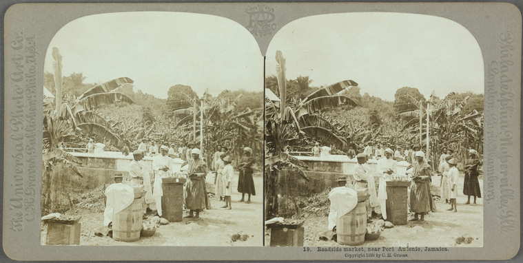
What the planters had not counted on was surplus. A family that could work a steep acre well grew more than it could eat, and the surplus had somewhere to go. Every Sunday, the one day the estate did not own, enslaved farmers walked and paddled their produce to the nearest town and sold it.
The scale of this is hard to overstate. The planter-historian Bryan Edwards reckoned that 10,000 people gathered every Sunday in the Kingston market alone, and smaller versions of it ran in every port on the coast. Nobody else was growing fresh food in quantity. White townspeople, soldiers, sailors and merchants bought their yams, plantains, fruit, fowls and fish from enslaved people, or went without.
That trade was paid for in coin, and the coin stayed in the hands of the people who earned it. By 1775, by one estimate drawn from Edward Long's own figures, enslaved Jamaicans held roughly one-fifth of all the currency circulating on the island. By the 1830s, something like a third of Jamaica's agricultural output was coming off provision grounds, not estates. Long himself, no friend to the enslaved, recorded that an industrious grower might put by 50 pounds or more, and that some used the money to buy their own freedom, a few shillings at a time.
The market was a woman's world. Women carried the loads, set the prices, haggled, extended credit and ran the stalls; the English word for a small-time dealer, higgler, attached itself to them and never let go. The market was also a news network. People from twenty estates met in one square, out of earshot of any overseer, and what travelled home with the empty baskets was information: who had run away, which estate had a new attorney, what the ships in the harbour were saying about the war in Saint-Domingue.
The planters understood this, and they did not like it. The Assembly had been passing laws to regulate Sunday markets since 1744; Barbados tried in 1774 to ban enslaved people from displaying goods on any stall, bench or tray in Bridgetown. None of it worked. The island had become dependent on the very people it was trying to control, and everyone knew it.
Chapter 05
The water road
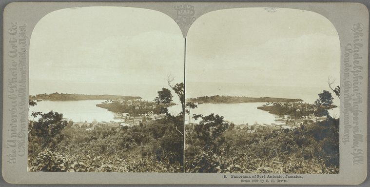
On the north-east coast, the road to market was often the sea. Portland is cut by seventeen rivers running off the Blue Mountains, the biggest of them the Rio Grande, and the ridges between them made overland travel slow and brutal. A canoe launched where a river met the sea could reach Port Antonio's twin harbours in a morning. Generations later, when bananas replaced sugar, Portland farmers would float their fruit down the Rio Grande on bamboo rafts for the same reason; the rafting tourists ride today began as cargo.
The people doing the paddling had brought the skill with them. The historian Kevin Dawson has shown that many West Africans were fishing farmers and farming fishermen, who used dugout canoes to carry goods to market at home and carried the craft, and the canoe-building, across the Atlantic. In Caribbean ports, fleets of enslaved fishermen in African-style dugouts parted to let ships in. Enslaved women paddled out alongside anchored vessels to sell fresh produce, seafood and curiosities straight over the rail. Enslaved boatmen ferried newcomers ashore and worked the cargo. Dawson's conclusion is blunt: the stability of these colonies, and white people's dinners, depended on enslaved women being able to own canoes and sell what they grew and caught.
That is the world Bourbon's farmers belonged to. A ship that had been six weeks at sea wanted fresh water, firewood, fruit and fowls, and would pay in coin or cloth to the first canoe that reached it. A canoe that reached a ship before it docked had cut the town merchant out of the bargain entirely.
The sea cut both ways. In 1781, in the middle of the American war, the planter Simon Taylor complained that Spanish raiders were working the Jamaican coast and carrying off enslaved people from the estates. The same open water that let a canoe reach a merchant ship let anyone else reach the shore. Nobody on this coast ever controlled it fully, and that fact shaped everything the lawmakers tried next.
Chapter 06
Laws against the sea
The law books of the British Caribbean read like a long argument with the coast. From Jamaica's first slave codes in the 1660s, an enslaved person found off the estate without a written ticket from the owner could be seized, and the fine print grew thicker with each revision through 1696, 1788 and beyond. The Assembly threatened ship captains who carried enslaved people off the island. In 1790 Nevis forbade enslaved people to sell livestock, meat, sugar or rum without a ticket; in 1789 Grenada went further and ordered every owner of a canoe, boat or pettiauger to take out a licence and post security that the vessel would not help an enslaved person escape.
Read together, these laws describe what the lawmakers feared, which is the best evidence we have of what was happening. A canoe was mobility. Mobility meant trade the planter did not control, news the overseer did not hear, and a route off the island.
The fear sharpened after 1791. When the enslaved of Saint-Domingue rose and, over thirteen years, destroyed slavery there and founded Haiti, every planter on Jamaica's north coast was suddenly looking at the Windward Passage. Portland's coast faced it. The idea of a Jamaican boatman trading news with a Haitian sailor at anchor stopped being a nuisance and became a nightmare, and the market, the canoe and the hillside ground all came under harder scrutiny. In 1807 the colonial authorities exposed a conspiracy in the island and one informer went so far as to accuse the Charles Town Maroons, the free Maroon community in the hills to the west of Bourbon, of being part of it.
And still the trade went on. It went on because it could not be stopped without starving the towns, and because the coast of Portland, with its seventeen river mouths and its mountains at its back, was never a place the plantation could fully watch.
Chapter 07
The mountain at their back
Every farmer on Bourbon's hillsides worked within sight of free Black country. Up the Rio Grande, above the last estate, was the territory of the Windward Maroons, the people who had escaped the plantations, fought the British to a standstill in the 1730s and forced a treaty. Their first stronghold, Nanny Town, was hidden so well that the British did not find it until an African guide led them there in 1728, and it held out for years before it fell. In 1739 the Windward leader Quao signed the peace that recognised the Maroons as free, and Nanny, the woman who had led them, is buried at Moore Town in the Rio Grande valley. She is Jamaica's only National Heroine.
After the treaty, the Maroons who had held Crawford Town high in the Blue Mountains came down to Charles Town on the Buff Bay River, about nine miles west of Bourbon, where their descendants still live and still sound the abeng. There were 226 Maroons at Charles Town in 1770 and 289 by 1797: a small community, but one that owned its land, kept its own law and answered to a colonel of its own choosing.
For the colony, the Maroons were a border and a threat. The government had tried to settle Portland with land grants in the 1720s precisely because the Maroons were there, and the settlers it sent were, in the words of one parish history, useless against them. For the enslaved, the Maroons were something more complicated: by treaty they were obliged to return runaways, and sometimes did, yet they were also living proof that the mountains could be held.
That proof mattered on market day. A woman walking her yams down from Bourbon to St. Margaret's Bay was walking between two worlds, the estate below her and the free hills above, and she carried news from both. The provision grounds, the Sunday market and the Maroon towns were three corners of one triangle, and the plantation sat uneasily in the middle of it.
Chapter 08
What Bourbon became
When slavery ended in 1834 and the apprenticeship that followed it ended in 1838, the people of Portland's hills did not have to invent a new way to live. They already had one. The provision ground became the smallholding, the Sunday market became the weekly market, and the higgler, now free, became the backbone of Jamaica's internal food economy, which she remains. Sugar never recovered on this coast. Bananas did, from the 1870s, and Portland's small farmers floated their bunches down the Rio Grande on bamboo rafts to steamers at Port Antonio, which made the town Jamaica's first tourist resort.
The map caught up with the people in 1867, when the old Parish of St. George was folded into Portland and Bourbon's neighbourhood stopped straddling a line. There is an Anglican church, St. Jude's, at Bourbon; the diocese still lists it in the Portland deanery.
The district's most famous son was born in a shop. On 2 June 1939, Egbert and Lolita Lee, shopkeepers in Bourbon, had their first child and only boy. According to his own telling, the village prophetess advised them to name him Emmanuel, because he would be a leader of men. George Egbert Emmanuel Lee became a journalist, stood at the centre of the 97-day JBC strike of 1964, and in 2003 became the first directly elected mayor of the municipality of Portmore, a post he lost in 2007 and won back in 2012. When he died in 2013, the government gave "Mr Portmore" an official funeral. The hills of Bourbon had sent another trader's child down to the coast to make a mark.
The woman digging yams in the dark would not recognise much of the Portland of today. But she would know the market. She would know the road down to St. Margaret's Bay, and the rafts on the river, and the sound of a higgler calling out her prices. The island she helped feed still eats from her hands.
A note on the record
The opening scene is a reconstruction, built from what the records say about hillside farmers across Jamaica; no diary from Bourbon itself has survived, or at least none has turned up. Everything after it rests on the sources below, with these cautions:
- Bourbon's position (the hills between the Rio Grande and the Swift River, about five miles from Port Antonio) comes from current land records. Which side of the old Portland–St. George line it sat on before 1867 could not be confirmed from the sources available; early registers should be searched under both parishes.
- The Otaheite/Bourbon cane of the 1790s is a possible explanation of the name, presented here as a hypothesis; no document spelling it out has turned up, and no estate called Bourbon appeared in the St. George or Portland entries of the slavery compensation records that were checked.
- The one-fifth-of-the-currency figure (1775) and the one-third-of-output figure (1830s) come from Barickman (1994) as cited by Tookes, and trace back to Edward Long's own estimates, which modern historians treat as rough.
- Canoe trade alongside anchored ships is well documented across the British Caribbean (Dawson), but no Portland-specific account of it was found.
- Several details that circulate about this history could not be verified and were left out: a Jamaican law banning enslaved people from canoes (the closest statute found is Grenada's 1789 licensing act); Royal Navy cutters patrolling for canoes; Maroons trading arms with Spanish or French ships; George Liele's preaching stations reaching this district; and a recent bridge at Bourbon. Two dates in circulation are also off: the Bourbon cane reached Jamaica in 1793, not 1796, and Jamaica's first consolidated slave act was 1788, not 1792.
Sources & further reading
Research references accompanying the historical essay. The note above identifies the gaps and uncertainties in the record.
- Durham district land records, Portland — parcels named Bourbon, Burbon Road
- Portland history, Jamaica 55 — 1723 land grants, Maroons
- Portland Municipal Corporation: history — rivers, rainfall
- The story of the parishes, Gleaner — 1867 reduction to 14 parishes
- Lāhainā / Bourbon / Otaheite cane, University of Hawaiʻi — Bligh's cane and its names
- Mulcahy, Hurricanes, Poverty, and Vulnerability — 1780s storms, 1787 Assembly inquiry, 15,000 dead
- Simon Taylor letters, University of Southampton — ground provisions, Spanish raiders
- Jamaica slave law of 1826, Laws of Enslavement and Freedom — one day a fortnight, 26 days a year
- Tickets tag, Laws of Enslavement and Freedom — Jamaica, Nevis and Grenada acts
- Tookes, Traveling to Market (2019) — currency, output, higglers
- Manumission in late eighteenth-century Jamaica, ScienceDirect — Long on enslaved savings and self-purchase
- Transatlantic slavery and Caribbean farmers' markets, University of Liverpool — Edwards' 10,000 at Kingston market
- Dawson, For Some Enslaved Africans, Water Was a Savior — canoes, fishing, trade with ships
- Breadfruit: the forgotten gem, Gleaner — 1793 introduction, rejection by the enslaved
- Charles Town Maroons, Blue and John Crow Mountains and Charles Town, Wikipedia — Quao, Crawford Town, 1770 and 1797 counts, 1807 accusation
- Portland parish profile, JIS — Nanny Town found in 1728, Moore Town
- Rafting on the Rio Grande, Visit Jamaica — rafts as banana transport
- Anglican Diocese of Jamaica: churches — St. Jude's, Bourbon
- George Lee: 'Mr Portmore' is back, Jamaica Observer and Official funeral, JIS — birth in Bourbon, career
About the photographs
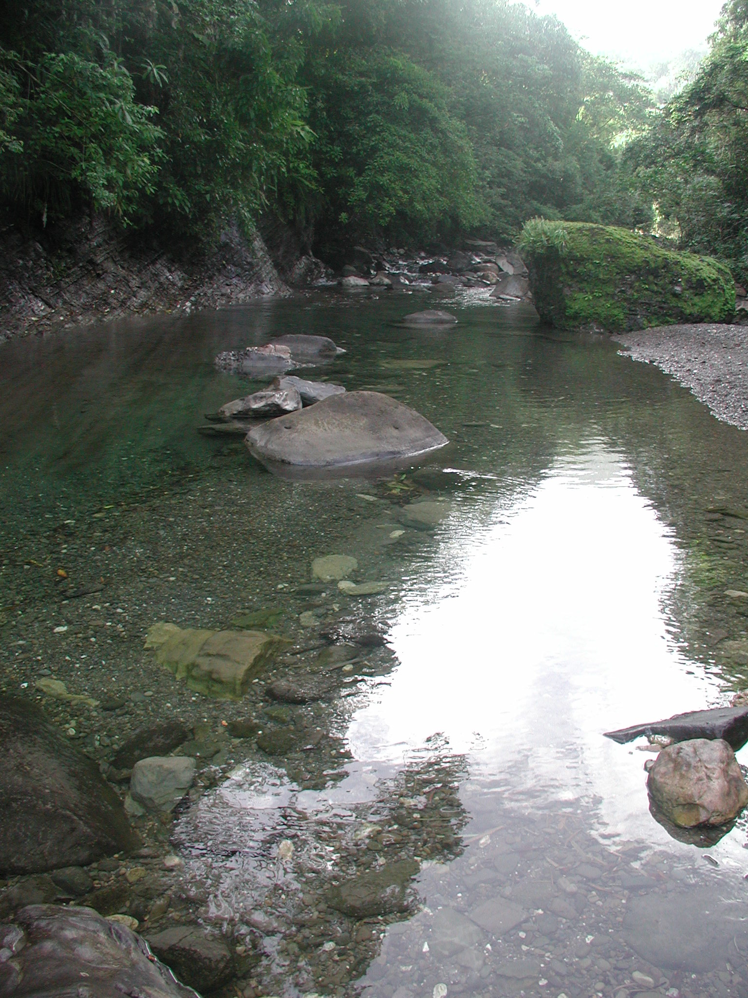
Morning in the Rio Grande Valley, Jamaica, Michael L. Dorn, 1 June 2004. CC BY-SA 2.0. Original photograph, reproduced without alteration.
Roadside market, near Port Antonio and Panorama of Port Antonio, Carleton H. Graves, published before 1930. Public-domain stereographs from the New York Public Library, via Wikimedia Commons. Shown in full, including their paired views. These later photographs do not depict the reconstructed scene in the 1790s.